News broke on Monday from Yarra Council meeting agenda that new stormwater flood map modelling designate 22,179 properties as being liable to flooding – just over a third of the 60,037 properties in the City of Yarra municipality. This includes the suburbs of Fitzroy, Collingwood and Richmond.
The article also reported that Merri-bek City Council is also updating its own stormwater flood modelling. The Age reported that about 12,000 properties have been marked as at additional risk from stormwater flooding, based on a November 2023 updated stormwater map prepared by expert drainage engineers.
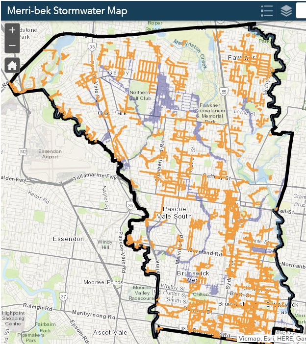
The new stormwater maps came into effect on 30 November 2023. Those properties notionally affected were consulted in 2021 and 2023, according to Merri-bek Council. (See Conversations Merri-bek on Stormwater map for land development) Merri-bek Council provides an online tool for residents to put in their address to see if their property is at risk.
Planning Amendment C196more is presently going through the decision process to a Planning Panel. Council is proposing to apply a Special Building Overlay – Schedule 2 (SBO2) to properties affected by stormwater overland flows in the city’s local drainage areas.
The Evgeny Technical report notes that “Council’s current drainage standard for residential areas is a 20% AEP (1 in 5 year) event sized pipe. It is likely that this standard was applied when pipes were originally constructed across the city. By adopting a 10% AEP (1 in 10 year) event, Council is providing extra flow capacity above the minimum design standards.”
The report details that of the 80,180 land parcels in Merri-bek, 7,159 land parcels are directly impacted by the 1% AEP ( 1 in 100 year flood risk). This is a result of Climate Change produced Council stormwater overland flow paths in the local drainage catchments where Council is the local drainage authority. This amounts to about 9% of all land parcels.
Earlier flood map modelling from 2018 assessed areas most at risk of inundation. Council has been working on a prioritised list of projects to address the stormwater overland flows in these locations, based on the cost to benefit ratio of reducing the risk of stormwater flows at each location. This has fed into Council capital works planning for structural mitigation projects.
This is essential climate adaptation mitigation work that generally passes by without public notice, and often little notice even by Councillors.
Here are Just a few example of items passing through Council meetings on flood mitigation:
- At the 10 July 2024 Council meeting item 7.11 Contract Award: RFT-2023-570 – Dunstan Stormwater Harvesting Project will be voted upon. This is important for managing stormwater, flooding, irrigation of sportsfields in time of drought. Also contributes to urban cooling. The stormwater harvesting system can contribute to mitigating local flooding, as well as provide water for irrigation and urban cooling.
- The June 2024 Council meeting had some flood mitigation work projects moved to the 2024/25 capital works program according to the Financial Management Report For The Period Ended 30 April 2024.
- Council meeting 8 December 2021 item 7.23 Contract Rft-2021-229 Drainage Improvement Works Along Barry Street, Collier Crescent And Fallon Street, Brunswick addressed localised flooding along Barry Street, Collier Crescent and Fallon Street, Brunswick during storm events which have impacted a number of properties within the catchment. Climate change impact is prevalence of more intense rainfall events.
Question to Council on Flood Risk in Merri-bek
View a one minute youtube clip of the question asked at Council Meeting. The question on Flood risk in Merribek was asked by Climate Action Merri-bek Convenor John Englart:
- 1.07.30 Question on Flood Risk by John Englart (to 1.08.51)
- 1.09.03 Answer by Director Phil Priest (to 1.11.12)
- 1.12.10 Clarification Question by Cr Pavlidis (to 1.13.50)
- 1.13.52 Cr Bolton requests a statement on flood risk be published on Council website (to 1.14.35)
Question on Merri-bek Council flood mitigation engagement with property owners and what ongoing work with Melbourne Water to mitigate stormwater overland flow flood risk due to the climate emergency.
Answer from Director Phil Priest: During 2021 and 2023 Council has engaged and consulted with existing property owners that have suffered inundation. The Planning amendment that is currently being put forward will cover 12,000 additional properties. This makes it clear to property developers to put in adequate stormwater infrastructure.
Qustion from Cr Pavlidis :asked whose responsibility is flooding/innundation from properties already impacted. Priest avoided answering the question directly. Said Planning amendment would extend to 12,000 properties.
Cr Bolton asked if the Planning Department could put up a statement on the website re flood risk as it is in the news. There appeared to be general assent for this to happen from the Mayor.
Dunstan Reserve Stormwater Harvesting Contract
During the item on the Contract for Dunstan Reserve Stormwater harvesting there was some mention of the issues raised in the question on stormwater flooding. This included stormwater harvesting helping to prevent flood risk and providing environmental benefits in filtering the water of pollution, and in water supply for irrigation (sports fields in time of drought) and urban cooling by Cr Tapinos and Cr Riley.
Dunstan Reserve stormwater harvesting project is the fifth major water harvesting project in Merribek.
“Stormwater runoff from approximately 50 hectares of residential area will be diverted into a raingarden in the north-east of Dunstan Reserve. The runoff will be filtered as it percolates through the raingarden (a sandy vegetated area) and will then drain into an underground tank. Water will be drawn from the tank, disinfected by Ultra Violet light treatment, and then used to water the ovals and community gardens. The raingarden will be planted with native plant species that will increase the biodiversity of the park and provide habitat and food for insects and birds.” – Conversations Merribek
There is also a small biodiversity benefit gained in building stormwater harvesting and storage in creating artificial wetlands that encourages wetland amphibians, birdlife, insects and vegetation.
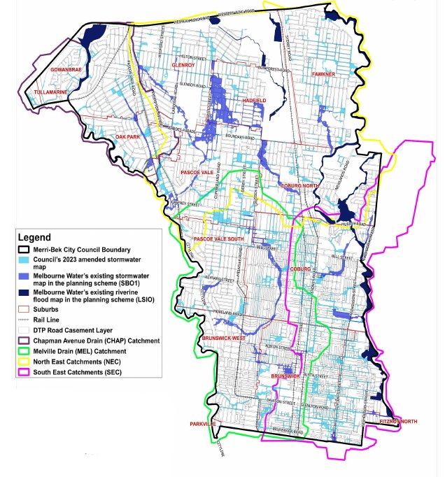
Merri-bek stormwater flood map
The following map shows all layers, both Council and Melbourne water catchment and stormwater overflow flood risk. It is on the Conversation Sormwater Merribek Flood risk page. Residents can also put in their address to determine if their property has a flood inundation risk from a 1 in 100 year extreme rain fall event.
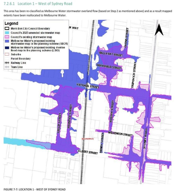
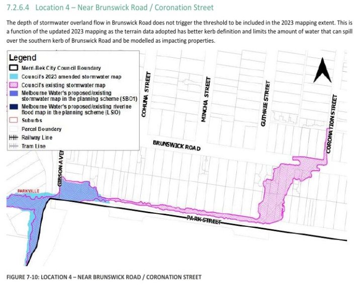
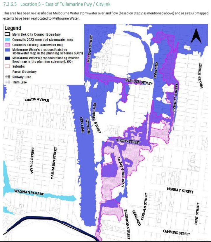
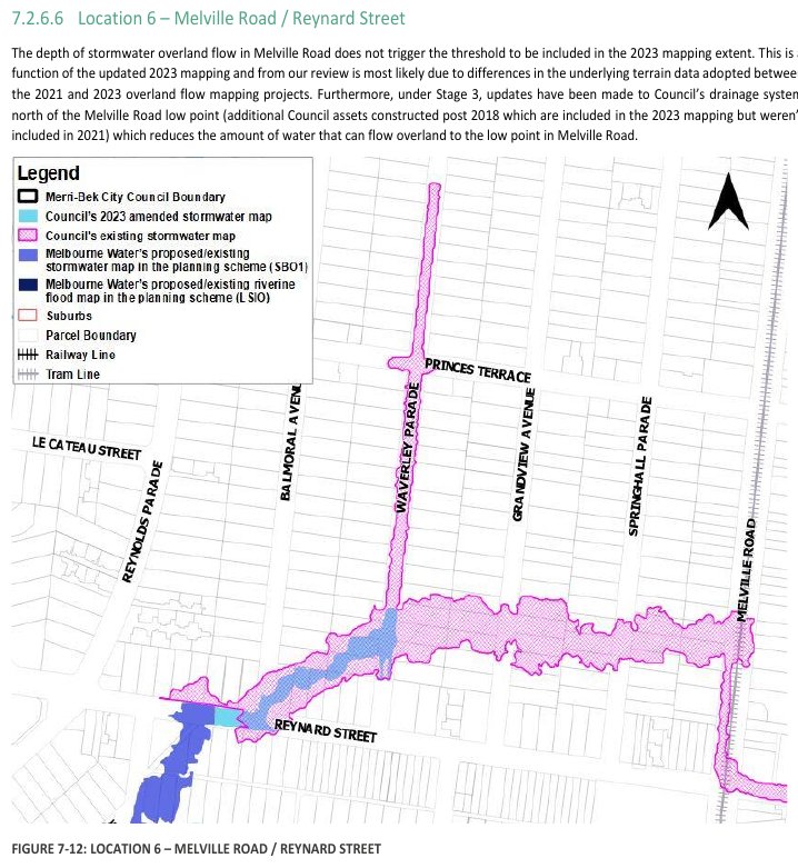
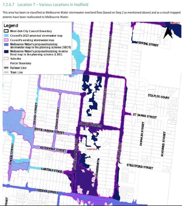
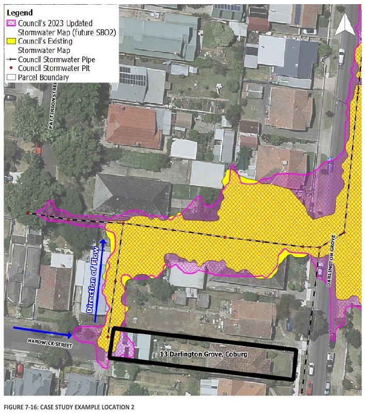
Detailed Flood Maps examples for specific area
The following maps are specific examples cited in the Technical Document, and don’t represent all the overflow flooding. You should refer to the November 2023 Technical report Merri-bek City Council Creating the Local Drainage Authority’s Stormwater Map Technical Report (PDF) for full context.


Climate Council 2022 Flood map tool
The Climate Council developed a tool to highlight the growing risk of both riverine and stormwater flooding for Merribek properties in 2022. It assessed a high flooding risk by 2030 to 1295 properties by 2030, 1376 properties by 2050, 1848 properties by 2100. (See 4 May 2022, Climate Risk mapping for Moreland: climate impacts and insurability),
19th and 20th Century drain infrastructure no match for 21st century climate
Stormwater flood risk and overland flow is quite different from riverine flood risk. Much of our stormwater drainage systems were built in the mid to late 19th Century and the 20th century.
Due to a warming climate more intense rainfall can be expected. We have also built out many of our city surfaces with hard surfaces: roofs and roads that carry the rain quickly to stormwater drains that weren’t built for the capacit of the increased water flow, hence flash flooding occurrs.
This is another reason we need more green roofs to soak up the water, parklands and rain gardens to slow the water flow.
But our drainage systems also needs to be assessed and upgraded to meet the capacity of increased rainfall.
Increased flood risk drives insurance premium increases
The other issue this creates is that more properties subject to stormwater flood risk will increase insurance premiums both for affected postcodes, plus across the board. Our insurance premiums will increase because we have failed to reign in fossil fuel extraction and expansion fast enough causing global warming and the rise in temperatures.
References
Sophie Aubrey, The Age, 9 July 2024, Flood risk for more than 22,000 inner Melbourne properties, new modelling shows https://www.theage.com.au/national/victoria/flood-risk-for-more-than-22-000-inner-melbourne-properties-new-modelling-shows-20240708-p5js0z.html
Merri-bek Council Amendment C196More details a Planning overlay for the updated stormwater flood risk map , https://www.merri-bek.vic.gov.au/building-and-business/planning-and-building/strategic-planning/current-amendments/amendment-c196/
2023 Stormwater Map from page 16 of November 2023 Technical report Merri-bek City Council Creating the Local Drainage Authority’s Stormwater Map Technical Report, https://www.merri-bek.vic.gov.au/globalassets/website-merri-bek/areas/building-business/planning-and-building/strategic-planning/current-amendments/c196/c196more_exhibition_background-document_technical-report_creating-the-local-drainage-authoritys-stormwater-map.pdf
Climate Action Merribek, 4 May 2022, Climate Risk mapping for Moreland: climate impacts and insurability, https://climateactionmerribek.org/2022/05/04/climate-risk-mapping-for-moreland-climate-impacts-and-insurability/
Conversations Merri-bek landing page on Stormwater map for land development, https://conversations.merri-bek.vic.gov.au/stormwater

[…] is already driving up Insurance costs, whether you live in a high risk zone or not. There are now 12,000 properties in Merribek now at flood risk due to climate change. Over 20,000 people are vulnerable in Merribek to extreme heat. Both […]
LikeLike