In mid December, the state government changed the planning scheme to reduce the number of car parking spaces required in new developments. The aim is to reduce traffic congestion and the cost of housing. They are particularly targeting areas well served by public transport. However, most of Merri-bek is impacted by these changes. It will affect not only new housing but also non-housing developments. These changes greatly strengthen the argument for much better public transport, particularly in the north of Merri-bek, and more safe walking and cycling infrastructure.

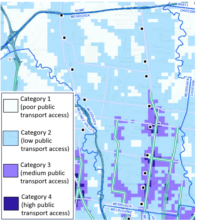
Areas have been classified according to public transport access. Details on calculations here.
- Category 1 (white areas – poor public transport access): very little change to parking requirements.
- Category 2 (light blue – low public transport access): car parking requirements (minimums) have been halved for many type of developments.
- Category 3 (purple – medium public transport access) and Category 4 (dark blue – high public transport access) very large reductions in car parking requirements.
Most of Merri-bek is in Category 2. The map for the whole of Merri-bek is shown below. To find the new car parking requirements in your area go to https://mapshare.vic.gov.au/vicplan/. Under Layers select “Car Parking Requirements Maps”. Note that these maps will be refined over time. They are currently a coarse grid.
The requirements for accessible parking spaces for people with disabilities have not changed. Developers can also apply to for a permit to vary the minimum or maximum car parking rates.
Previously developers could apply for a reduced number of car parking spaces in planning applications. And often they did. This would lead to residents objecting to these developments on the grounds of insufficient car parking, and councillors spending much time in planning meetings debating these.
“Councillors will need to re-think the value of private car parking when other transport options are available. These changes should reduce a lot of debate and time in Council planning meetings” – Mark Riley (former Merri-bek Councillor)
Housing
Consider housing developments. Here are the new car parking requirements.
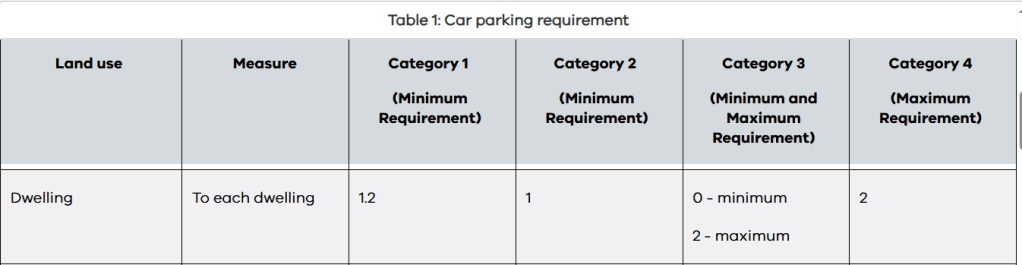
For housing in category 3 and 4 areas, developers are required to provide between zero and two car parking spaces per dwelling. In Category 2, they are required to provide at least one car parking spaces (with no maximum). Previously dwellings with one or two bedrooms were required to have at least one car parking spaces, while dwellings with those three or more bedrooms were required to have at least two spaces.
There have been a few apartments approved with zero car parking in Merri-bek,, but these have been controversial. In 2018, Merri-bek found that having a car parking space increased the purchase price of an apartment by 15% or more. People who want to buy or rent a home typically have to pay for a car parking spot even if they had no need for it. As the graph below shows, over a quarter of apartment dwellers in Merri-bek do not have a car. This suggests that residents should have the choice not to have to pay for unwanted vehicle storage space.

Other types of developments
There are many other land uses where car parking requirements have changed. For example:
- Supermarkets and other shops: The number of car parking spaces required in category 2 areas have been halved. Those in category 3 and 4 areas no longer require car parking.
- Child care: The reductions are similar to those for supermarkets and shops
- Places of assembly (including places of worship): In category 3 and 4 areas, car parking is no longer required. In category 4 areas, the maximum allowed number of car parking spaces is 1 for every 12.5 patrons.
- Medical centre: The number of car parking spaces required in category 2 areas have been reduced by nearly one third. Those in category 3 and 4 areas no longer require car parking.
The need for better public transport
These changes bring home the need for much better public transport – particularly on the Upfield rail line and on buses. The map below shows that most of Merri-bek is light blue, particularly in the north and the west. This indicates they have low public transport access. Yet there are some parts in white – the areas with poor public transport access. These include:
- Coburg Hill, where there is currently a campaign to upgrade the 526 bus service.
- Large parts of Glenroy, apart from the area close to the Craigieburn rail line, and parts of Hadfield. These areas are served by the 536 bus. There has been a successful campaign to get Sunday services on this route (which have not yet started), but clearly much more needs to be done.
- Gowanbrae.
Timed Parking restrictions
Merri-bek tried to introduce reduced car parking requirements for new developments in 2019. They also started rolling out timed parking restrictions in areas that would have been eligible for zero parking developments. This was essential to stop people just parking on the street. Only residents whose property was subdivided BEFORE August 2011 are eligible for residential parking permits. Those in newer developments are not. But in 2020, Council abandoned the rollout of timed parking restrictions and the attempt to introduce reduced car parking requirements.
Given that the state government has stepped in and done what Merri-bek failed to do, it is essential now that Council introduce timed parking restrictions. But Council’s process for changing parking restrictions is cumbersome. We hope that they will reconsider rolling our bulk timed restrictions. More paid parking will be required, including for kerbside parking in busy areas, as is done in comparable councils. As pressure on car parking increases, other methods of managing parking will be needed. An example is demand-responsive parking charges. These are intended to ensure that there will are always be a few vacant car parking spaces.
The state government also has a scheme where people with mobility challenges (but who can walk more than 100 metres) may be eligible for a Double Time Accessible Parking Permit, allowing them to park for double the time on the signs. The eligibility criteria for the Double Time Accessible Parking Permit are nowhere near as stringent as for a Disability Parking Permit. Once timed parking restrictions are introduced, more car parking spaces will be available for people with mobility challenges. So residents with mobility challenges will benefit from timed parking restrictions.